
Science
NIT Rourkela Partners with Survey of India to Enhance Geospatial Research

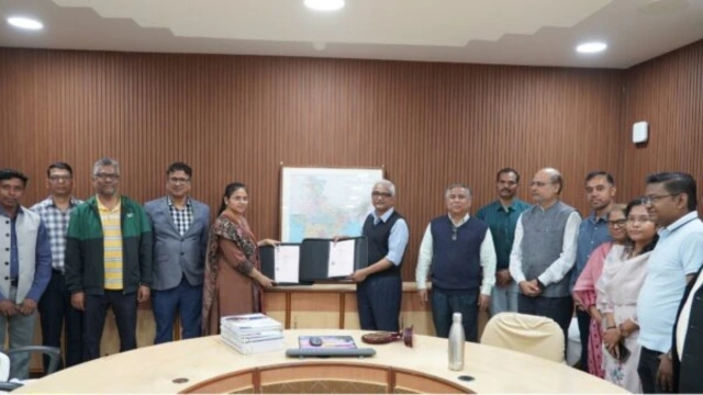
The National Institute of Technology Rourkela has established a collaborative agreement with the Survey of India aimed at advancing research and technological development in geospatial science, mapping, and earth observation. This strategic partnership will involve the Odisha and Chhattisgarh Geospatial Directorate of the Survey of India and is designed to leverage institutional expertise in areas such as national mapping, geodesy, remote sensing, and climate science.
The agreement, signed for a duration of five years, will facilitate joint research projects, technical exchanges, and academic collaboration that aligns with the objectives of India’s National Geospatial Policy 2022. Under this partnership, NIT Rourkela will contribute its research expertise in geodynamics, earth sciences, and environmental monitoring, while the Survey of India will provide access to essential national mapping infrastructure and comprehensive geospatial datasets.
Strengthening Scientific Capabilities
The collaboration is expected to bolster scientific capabilities in areas such as digital mapping, infrastructure planning, and environmental assessment. Geospatial technologies are pivotal for these applications, allowing for precise terrain analysis, location intelligence, and real-time data integration, which are critical for informed decision-making.
A key focus of this partnership will be the development of solutions for climate monitoring, disaster risk assessment, and sustainable urban and infrastructure planning. By combining technical expertise with robust infrastructure, the initiative aims to support innovation within the geospatial sector and contribute to national development priorities.
The agreement also includes provisions for specialized training, technical consultation, and access to advanced research facilities. NIT Rourkela will conduct advanced geodetic surveys and offer academic training opportunities, while personnel from the Survey of India will benefit from NIT Rourkela’s research resources and expertise.
Utilizing National Geospatial Infrastructure
An important aspect of this collaboration is the utilization of national geospatial infrastructure, including Continuously Operating Reference Stations. These systems facilitate precise positioning and high-accuracy mapping, which are essential for various applications such as infrastructure development, land management, disaster response, and scientific research.
This partnership reflects a broader initiative to enhance India’s geospatial ecosystem by integrating academic research with national mapping capabilities. By merging technical expertise and infrastructure, the collaboration is poised to drive advancements in geospatial technologies and promote sustainable development in planning, environmental management, and infrastructure expansion.

Albert Camus’ Insightful Quote on Human Identity Resurfaces

Drone Strikes and Missile Attacks Disrupt UAE Amid Rising Tensions

Japanese Yen Rises Sharply Against US Dollar Ahead of Key Decisions

Priyanka Chopra and Nick Jonas Avoid Near Miss en Route to Oscars

Gujarat Vaccinates Over 11 Lakh Infants in Major Health Drive

Alexandre Singh Wins Oscar, Celebrates Immigrant Heritage

Lok Sabha Speaker Issues Warning Over Placards in Parliament

Global Electrosurgical Devices Market Expands to $10.2 Billion by 2034

North Zone Dominates Cricket; SJAM-1 Shines in Table Tennis

SBI Announces QIP Floor Price at ₹811.05 Per Share

Cept Unveils ₹3.1 Crore Urban Mobility Plan for Sustainable Growth

New Blood Group Discovered in South Indian Woman at Rotary Centre

Konkani Cultural Organisation to Host Pearl Jubilee in Abu Dhabi

Torrential Rains Cause Flash Flooding in New York and New Jersey

Nothing Headphone 1 Review: A Bold Contender in Audio Design

Air India Crash Investigation Highlights Boeing Fuel Switch Concerns

Indian Stock Market Rebounds: Sensex and Nifty Rise After Four-Day Decline

Broad Advocates for Bowling Change Ahead of Final Test Against India
-
 World1 year ago
SBI Announces QIP Floor Price at ₹811.05 Per Share
-
 Lifestyle1 year ago
Cept Unveils ₹3.1 Crore Urban Mobility Plan for Sustainable Growth
-
 Science12 months ago
New Blood Group Discovered in South Indian Woman at Rotary Centre
-
 Top Stories1 year ago
Konkani Cultural Organisation to Host Pearl Jubilee in Abu Dhabi
-
 World1 year ago
Torrential Rains Cause Flash Flooding in New York and New Jersey
-
 Science1 year ago
Nothing Headphone 1 Review: A Bold Contender in Audio Design
-
 Top Stories1 year ago
Air India Crash Investigation Highlights Boeing Fuel Switch Concerns
-
 Business1 year ago
Indian Stock Market Rebounds: Sensex and Nifty Rise After Four-Day Decline
-
 Sports12 months ago
Broad Advocates for Bowling Change Ahead of Final Test Against India
-

 Sports12 months ago
Cristian Totti Retires at 19: Pressure of Fame Takes Toll
-

 Politics1 year ago
Abandoned Doberman Finds New Home After Journey to Prague
-
 Lifestyle1 year ago
Villagers Unite to Raise ₹45 Lakh for Water Solutions in Vadgam