Lifestyle
Ahmedabad Firm Joins Consortium to Launch Indigenous Satellite Network
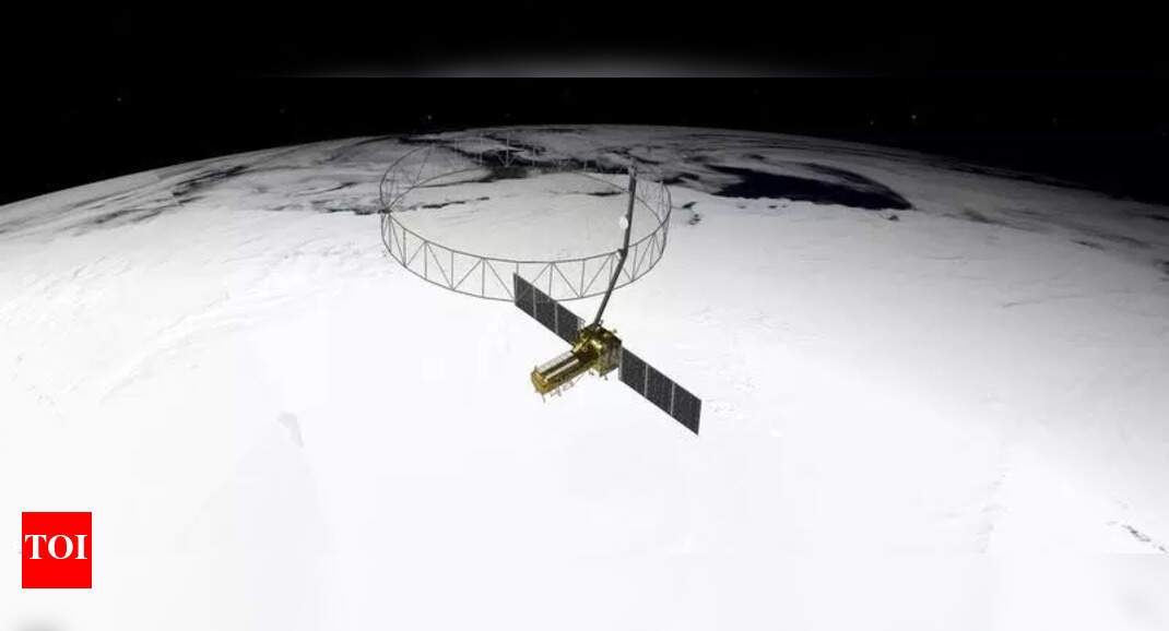
Ahmedabad’s PierSight Space has become a key player in India’s first fully indigenous commercial earth observation (EO) satellite constellation. The company joined a four-member private consortium selected by the Indian National Space Promotion and Authorisation Centre (IN-SPACe) to develop and operate this ambitious project, valued at Rs 1,200 crore. The initiative aims to deploy a network of twelve satellites equipped with synthetic aperture radar (SAR), providing continuous imaging capabilities regardless of weather conditions.
Innovative Public-Private Partnership
This pioneering public-private partnership, known as the EO-PPP model, marks a significant milestone in India’s space history. For the first time, a private consortium will fund, design, build, and operate an EO system. The consortium, led by PixxelSpace India, also includes Satsure Analytics India and Dhruva Space. The constellation is expected to be launched within the next five years, with the resulting EO data aimed at enhancing various critical sectors.
According to officials at IN-SPACe, the data collected will support vital areas such as climate change monitoring, disaster management, agriculture, infrastructure, marine surveillance, national security, and urban planning. The advancements in EO technology are anticipated to provide timely and accurate information, significantly benefiting both public and private sectors.
Transforming Earth Observation Capabilities
Gaurav Seth, co-founder and CEO of PierSight, emphasized the importance of developing SAR technology for effective Earth observation. “This programme ensures that India’s critical sectors will no longer have to wait for foreign data or compromise on timelines. Our constellation will put sovereign EO capabilities into the hands of Indian decision-makers, ensuring security, speed, and self-sufficiency,” he stated.
Adding to this perspective, Vinit Bansal, co-founder and CTO of PierSight, remarked that the mission extends beyond mere image capturing. “The real impact will stem from the context built over time, enabling insights that can drive decisions across both public and private sectors,” he noted.
Experts highlight practical applications of the SAR data, such as mapping flood zones and identifying landslide risks following severe weather events. This capability becomes particularly critical during the monsoon season when cloud cover can obstruct optical satellites. Industries such as mining, infrastructure, and logistics will also benefit from more accurate and timely intelligence, enhancing operational efficiency.
The collaboration among these firms not only reflects India’s growing capabilities in space technology but also represents a significant step towards self-reliance in critical data acquisition. As the project progresses, it is poised to reshape the landscape of Earth observation in India, ensuring that decision-makers have access to vital information when it is needed most.

Nitesh Rane Critiques Eknath Shinde Amid Rival Campaigning

India Can Lead Global HIV Response as New Treatments Emerge

WNBA and Players Association Extend CBA Negotiations Until January 9

Japan Plans Significant Hike in Residency Renewal Fees for Foreigners

Africa’s Forests Now Emit More Carbon Than They Absorb
UPI Transactions Surge 32% in November, Digital Payments Thrive

Swiss Voters Reject Hefty Inheritance Tax Amid Public Opposition

Archaeologists Uncover 2,000-Year-Old Papyrus in Egyptian Coffin

Bijan Robinson Dominates Week 13, Davante Adams Sets New Record

SBI Announces QIP Floor Price at ₹811.05 Per Share

Cept Unveils ₹3.1 Crore Urban Mobility Plan for Sustainable Growth

New Blood Group Discovered in South Indian Woman at Rotary Centre

Torrential Rains Cause Flash Flooding in New York and New Jersey

Konkani Cultural Organisation to Host Pearl Jubilee in Abu Dhabi

Broad Advocates for Bowling Change Ahead of Final Test Against India

Nothing Headphone 1 Review: A Bold Contender in Audio Design

Air India Crash Investigation Highlights Boeing Fuel Switch Concerns

Indian Stock Market Rebounds: Sensex and Nifty Rise After Four-Day Decline
-
 World5 months ago
SBI Announces QIP Floor Price at ₹811.05 Per Share
-
 Lifestyle5 months ago
Cept Unveils ₹3.1 Crore Urban Mobility Plan for Sustainable Growth
-
 Science4 months ago
New Blood Group Discovered in South Indian Woman at Rotary Centre
-
 World5 months ago
Torrential Rains Cause Flash Flooding in New York and New Jersey
-
 Top Stories5 months ago
Konkani Cultural Organisation to Host Pearl Jubilee in Abu Dhabi
-
 Sports4 months ago
Broad Advocates for Bowling Change Ahead of Final Test Against India
-
 Science5 months ago
Nothing Headphone 1 Review: A Bold Contender in Audio Design
-
 Top Stories5 months ago
Air India Crash Investigation Highlights Boeing Fuel Switch Concerns
-
 Business5 months ago
Indian Stock Market Rebounds: Sensex and Nifty Rise After Four-Day Decline
-

 Sports4 months ago
Cristian Totti Retires at 19: Pressure of Fame Takes Toll
-

 Politics5 months ago
Abandoned Doberman Finds New Home After Journey to Prague
-

 Top Stories5 months ago
Patna Bank Manager Abhishek Varun Found Dead in Well