Science
NASA-ISRO NISAR Satellite Achieves First Radar Imaging of Earth
On August 21, 2025, the NASA-ISRO Synthetic Aperture Radar (NISAR) satellite successfully transmitted its first radar images of Earth’s surface. This milestone marks a significant achievement in the collaboration between the National Aeronautics and Space Administration (NASA) and the Indian Space Research Organisation (ISRO). The mission is designed to enhance our understanding of the planet and support various scientific and practical applications.
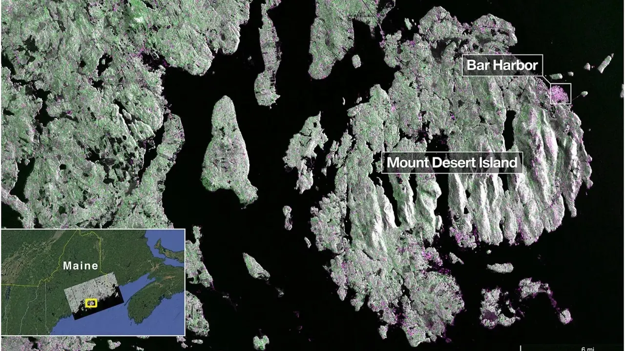
NISAR was launched on July 30, 2025, utilizing advanced radar technology to capture high-resolution images. The satellite’s initial images were taken of Mount Desert Island along the coast of Maine. In these images, dark areas represent water, green areas denote forests, and magenta highlights hard surfaces, including buildings and bare ground. The town of Bar Harbor is clearly visible, showcasing the radar’s ability to differentiate various types of land cover.
Just two days later, on August 23, NISAR captured additional images of Forest River in North Dakota. These images revealed a diverse landscape featuring wetlands, forests, farmland, and circular irrigation plots. The satellite distinguished between fallow fields and active crops, such as corn and soybeans, underscoring its capabilities in agricultural monitoring.
What sets NISAR apart is its unique combination of two radar bands: NASA’s L-band and ISRO’s S-band. This dual radar system allows for comprehensive data collection about Earth’s surface. Orbiting the Earth every 12 days at an altitude of 747 kilometers, NISAR can detect features as small as 5 meters, which enhances its utility in various applications.
The data generated by NISAR will play a crucial role in numerous fields, including disaster response to events such as floods, landslides, and earthquakes. Additionally, it will aid in agricultural monitoring to support food security, track climate change and ecosystems, and assist in urban planning and infrastructure management.
Sean Duffy, NASA’s Acting Administrator, commented on this achievement, stating that NISAR’s first images exemplify the potential of international collaboration. Full science operations for the mission are expected to commence in November 2025, promising advancements in Earth observation and environmental monitoring.
The joint effort between NASA and ISRO demonstrates how international cooperation can enhance scientific understanding and contribute to societal benefits. As NISAR embarks on its mission, its groundbreaking capabilities are set to transform our approach to monitoring and managing Earth’s resources.

Afghan Juice Seller’s Kindness to Indian Traveller Goes Viral

Russia and Iran Strengthen Scientific Collaboration at Conference

New Zealand PM Christopher Luxon Dazzles with Jalebi-Making Skills

Major Economies Face Rising Debt Crisis as Global Finances Strain

Triumph Launches Tiger Sport 800 Tour for Adventure Riders

Enhance Your Ad Campaigns Through Effective Landing Page Audits

Palash Muchhal Visits Ashram in Wake of Wedding Delay with Smriti Mandhana

Seven Ways 2026 Challenges Virgo to Emerge Stronger

Luana Lopes Lara Becomes World’s Youngest Self-Made Billionaire

SBI Announces QIP Floor Price at ₹811.05 Per Share

Cept Unveils ₹3.1 Crore Urban Mobility Plan for Sustainable Growth

New Blood Group Discovered in South Indian Woman at Rotary Centre

Torrential Rains Cause Flash Flooding in New York and New Jersey

Konkani Cultural Organisation to Host Pearl Jubilee in Abu Dhabi

Broad Advocates for Bowling Change Ahead of Final Test Against India

Nothing Headphone 1 Review: A Bold Contender in Audio Design

Air India Crash Investigation Highlights Boeing Fuel Switch Concerns

Indian Stock Market Rebounds: Sensex and Nifty Rise After Four-Day Decline
-
 World5 months ago
SBI Announces QIP Floor Price at ₹811.05 Per Share
-
 Lifestyle5 months ago
Cept Unveils ₹3.1 Crore Urban Mobility Plan for Sustainable Growth
-
 Science4 months ago
New Blood Group Discovered in South Indian Woman at Rotary Centre
-
 World5 months ago
Torrential Rains Cause Flash Flooding in New York and New Jersey
-
 Top Stories5 months ago
Konkani Cultural Organisation to Host Pearl Jubilee in Abu Dhabi
-
 Sports4 months ago
Broad Advocates for Bowling Change Ahead of Final Test Against India
-
 Science5 months ago
Nothing Headphone 1 Review: A Bold Contender in Audio Design
-
 Top Stories5 months ago
Air India Crash Investigation Highlights Boeing Fuel Switch Concerns
-
 Business5 months ago
Indian Stock Market Rebounds: Sensex and Nifty Rise After Four-Day Decline
-

 Sports4 months ago
Cristian Totti Retires at 19: Pressure of Fame Takes Toll
-

 Politics5 months ago
Abandoned Doberman Finds New Home After Journey to Prague
-

 Top Stories5 months ago
Patna Bank Manager Abhishek Varun Found Dead in Well